ALTIMETRY
Altimetry is the measurement of the height of the surface of the ocean - a contour map that is not visible to the human eye, but is detectable by satellite instrumentation and other data. The significance of the ss height is it is indicative of the location of upwelling currents (good) and downwelling currents (bad). When fishing, it is best to situate yourself in areas that have upwelling currents - these bring the cold, nutrient-rich water from the deep ocean up to the surface. When the nutrients near the surface they interact with sunlight, creating a chain reaction that goes right up the food chain. The pelagics migrate along inside these upwelling areas (Cyclones) as that's where the food is located. Since the warm water eddies are downwelling, they are pushing the nutrients down, thereby creating a "desert" - avoid areas that are colored yellow, orange, or red, as these indicate downwelling areas. Green is OK, as it's a transitional area and you will still catch fish there...look at the other data sets to make your final determination about where to go.
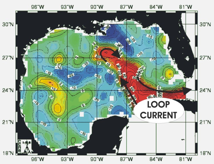
The driving force behind all of the currents in the Gulf (and much of the East Coast) is the Loop Current (shown below) which enters the Gulf between Cuba and the Yucatan, exits between Cuba and Florida, and becomes the Gulf Stream.
As the Loop Current stretches northward towards the Mississippi Delta, it will eventually stretch too far, and the end will break away forming a warm water eddy (as shown by the image below). The Loop Current and warm water eddies (anti-cyclones) rotate clockwise and generate counter-clockwise rotating currents called Cyclones. These cyclones are depicted by dark blue color and negative isobars (depressions on the contour map). The warm water eddies and cyclones are constantly migrating around the Gulf, growing or dissipating, and it's important to know which way they're migrating AND whether they are growing or dissipating.

Click here for an article from Texas A&M describing Altimetry.