
Introducing Hilton's Realtime Internet Map Server
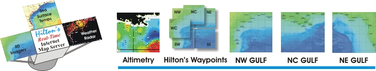
Hilton has developed a cost-effective online analysis tool to give anglers the edge in determining where to go at tournament time - Hilton's Realtime-Navigator! Providing unlimited access to the dynamic data such as; Sea Surface Temperatures, Altimetry, Water Color, Salinity, and Weather Radar, all geo-referenced to well-known waypoints in each region.
Did I mention that Hilton has also included thousands of waypoints located in the Subregion section?
Plan your fishing trip in the days leading up to your trip - determine tendencies and pinpoint the position of tempbreaks, water color change lines, and other points of interest. Use our Nav Tool to quickly and easily calculate the lat/long position, bearing, and distance to that point of interest from any waypoint shown in that region. Find the latest position of semisubmersibles and drillships, in addition to other pertinent info about them, such as date that they arrived on that position, lease block #, well depth, and in many cases, the future plans of the rig/ship, telling you when it will move off that spot and where it's going.
Click here to test-ride a demo of the service!
All contents of this website are copyrighted by Hilton's Fishing Charts, L.L.C. and may not be reproduced without written permission. Updated daily! ____
This site best viewed with Internet Explorer - Set display to 1024 x 768.